Urban Nodes & SUMPs
Urban nodes in the updated TEN-T regulation1
Europeans have the right to barrier-free, safe, and sustainable movement of people and goods across the Union. The Trans-European Transport Network (TEN-T) is an important driver for the improvement of European mobility of people and goods. The new TEN-T approach identifies 431 urban nodes along the Trans-European Transport Network (TEN-T).
By 2027, each urban node is expected to have a Sustainable Urban Mobility Plan (SUMP) in place, serving as a long-term, integrated plan encompassing all aspects of mobility within the functional urban area. These plans will prioritise sustainability, safety, and accessibility, with the goal of fostering efficient and environmentally friendly transportation systems.
By the same deadline, urban nodes are required to collect and submit urban mobility data to the European Commission. This data will cover key areas such as sustainability, safety, and accessibility, providing valuable insights for policy-making and infrastructure development.
To improve connectivity and address first and last-mile challenges, the development of multimodal passenger hubs is targeted for completion by 2030. These hubs will serve as central points for various modes of transportation, facilitating seamless transitions for passengers throughout their journeys, and providing access to public transport infrastructure and active mobility.
Urban nodes play a pivotal role within the TEN-T framework as they serve as cross-roads where different levels of transport networks converge.
This integration significantly enhances mobility across regions, fostering smoother transitions and connections between different transport modes of people and goods.
The integration also increases resilience of the network: if one link, hub or mode is impacted, other network sections or modes can answer to the transport demand.
Resilience plays an ever-increasing role when it comes to impact of climate change, stress on the network and possible disruptions due to geopolitical events.
The urban nodes concept can play a vital role in bridging the rural-urban mobility gap, facilitating comprehensive solutions that benefit urban, sub-urban and rural areas. The implementation of Urban Nodes Planning to the Functional Urban Area (FUA) is specifically important as are the intermodal passenger hubs that can create the physical link between urbanisations and the hinterland of the node.
Through strategic partnerships and collaborative initiatives, urban nodes mobilise diverse stakeholders to invest in transformative projects that enhance infrastructure, promote innovation, and mitigate climate change impacts.
Urban nodes and the SUMP increase the alignment of transport policy with economic, spatial, and environmental policies with the higher-level ambition to become resilient and climate neutral. The local and regional level is best suited to create cross-sectoral synergies.
Interdependency and complementarity can be strengthened thanks to the interconnection that the TEN-T brings.
Urban nodes can exchange knowledge, build skills and capacity together, sharing financial and digital assets.
Initiate or accelerate the dialogue with local, regional and transport authorities to establish the appropriate governance structures for the designated urban nodes;
Subsidiarity in governance – local must lead!
Governance capable of delivering a Functional Urban Area SUMP and Sustainable Urban Mobility Indicators (SUMI) values.
Stimulate an active collaboration between stakeholders vertically across governance levels and horizontally across sectors and disciplines. Note: special attention to cross-border Functional Urban Areas (FUAs) is needed.
Governance enabling establishment and operation of multi-modal infrastructure;
delivery of multi-modal infrastructure,
addressing complexities in project management,
transport network competence, and
financial stability and accountability.
Fiches released to support SUMP implementation2
On 24 April 2024, the European Parliament voted to update the guidelines so that all 431 urban nodes along the TEN-T network will have to adopt and monitor Sustainable Urban Mobility Plans (SUMPs) by 2027, and this was officially adopted in June 2024.
The Regulation text emphasises that "the local connectivity within urban nodes should be addressed by the competent local, regional, or national authorities, in particular through relevant measures of their sustainable urban mobility plans (SUMPs)."
In addition to monitoring SUMPs for each urban node, Member States should also ensure the collection of urban mobility indicators (UMI) per urban node in the fields of sustainability, safety and accessibility.
UMI indicator fiches were prepared for seven topic areas:
Greenhouse Gas (GHG) emissions
Congestion
Accidents and injuries
Modal share
Access to mobility services
Air pollution
Noise pollution
Each fiche includes information on: proposed input, output and result indicators; data requirements for urban nodes; indicator calculation methods; indicator logic; and definitions.
For reference, herewith two fiches whereby private-public collaboration between cities and Q-Park works at its best;
Urban node cities & Q-Park cities
Of the six countries in which Q-Park operates, note that the UK is not part of the EU, a total of 163 urban node cities were identified. In 76 of them, about half, Q-Park is present.
In two countries, Ireland and Denmark, there is a 100% match. In the Netherlands we have a match of over 70%, and in France and Belgium the match is just above 40% - making Q-Park an outstanding candidate for strategic partnership on local, regional and even national level.
Q-Park connects transport modes, is resilient and bridges the rural-urban mobility gap by providing access to public transport, off-street parking and sharing services of passenger cars and bicycles.
Download dataCountry | Urban node city | Q-Park city |
|---|---|---|
Netherlands | 26 | 19 |
Germany | 77 | 27 |
France | 42 | 18 |
Belgium | 11 | 5 |
Ireland | 3 | 3 |
Denmark | 4 | 4 |
Total | 163 | 76 |
For inspiration
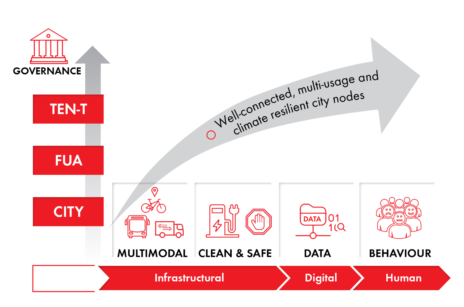
The SCALE-UP cooperation model relates to two ways of scaling up.
A vertical upscaling (Y axis) refers to integrating the mobility and transport strategies on multiple governance levels and beyond geographical boundaries (city, functional urban area (FUA), TEN-T) through collaboration with all stakeholders.
A horizontal upscaling (X axis), refers to addressing, in a balanced way, the different layers that shape the multi layered mobility system that we see today, being a physical or infrastructural layer, a digital layer, and the human layer referring to the central position of the end-user. To function as a data driven urban node all three layers need to be integrated in a balanced way.
MOVE21
The EU-funded project MOVE21 has been working on renewed collaboration models that consider the urban nodes approach and private-public collaboration. Based on insights from dedicated work, partner cities highlighted the need for more aligned or integrated policy planning related to mobility, logistics, infrastructure, energy, and spatial planning to deliver on the multiple targets of the cities while increasing liveability and attractiveness of cities as places to live, work and invest.
What are UMIs?
Urban Mobility Indicators (UMIs) are limited number of indicators covering the fields of sustainability, safety and accessibility. Those indicators will help urban nodes to monitor the implementation of SUMPs and provide feedback to cities and stakeholders. The indicators will also help urban nodes to monitor progress towards priorities identified in the TEN-T Regulation including:
promoting efficient and low-noise zero emission transport and mobility, including greening urban fleets for passengers and freight;
increasing the modal share of public transport and of active modes through measures to orientate primarily the mobility of passengers in favour of these modes, including safe and secure infrastructure for active modes, where appropriate;
promoting efficient low-noise and low-carbon urban freight delivery;
increasing accessibility and connectivity between urban and rural areas, and access to smart, sustainable and affordable transport.
The indicators allow for targeted steering of the implementation of these priorities. They help to identify the strengths and weaknesses of cities’ mobility systems. The data should allow to monitor progress towards the achievement of urban mobility policy objectives at the local, regional, national and European level, and for cities to take timely corrective action, where needed.
What is a SUMP?
A sustainable urban mobility plan (SUMP) is a strategic plan designed to satisfy the mobility needs of people and businesses in cities and their surroundings for a better quality of life. It builds on existing planning practices and takes due consideration of integration, participation, and evaluation principles.
A SUMP should cover the entire functional urban area (a city and its commuting zone), taking into account real traffic flows. A SUMP should foresee cooperation and synergies between all levels of government, local, regional, national and across different policy areas. It should be prepared in partnership with local residents and stakeholders. It ensures a variety of sustainable transport options for the safe, healthy and fluid passage of people and goods, with all due consideration for fellow residents and the urban environment.
- Source: Polis Network position paper https://www.polisnetwork.eu/wp-content/uploads/2024/04/Urban-Nodes-Alliance-Empowering-cities-and-regions-to-build-the-TEN-T.pdf
- Source: https://urban-mobility-observatory.transport.ec.europa.eu/news-events/news/new-urban-mobility-indicator-fiches-released-support-sump-implementation-2024-07-23_en